

You can find on this page the Houston metro map to print and to download in PDF. The Houston metro map presents the network, zones, stations and different lines of the metro of Houston in Texas - USA.
The Houston metro map shows all the stations and lines of the Houston metro. This metro map of Houston will allow you to easily plan your routes in the metro of Houston in Texas - USA. The Houston metro map is downloadable in PDF, printable and free.
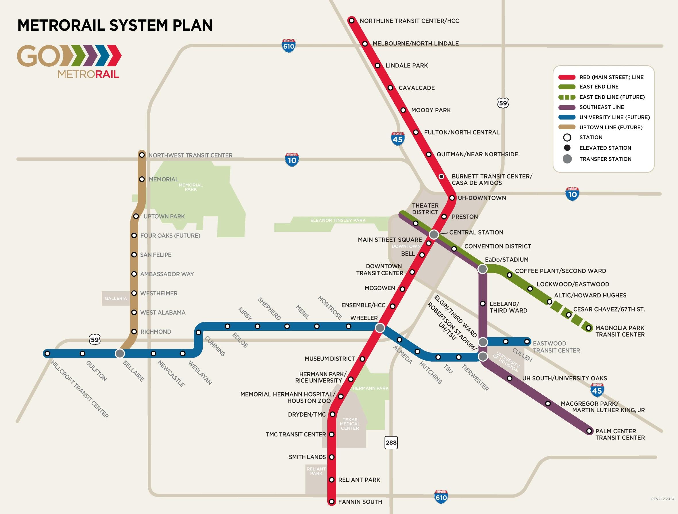
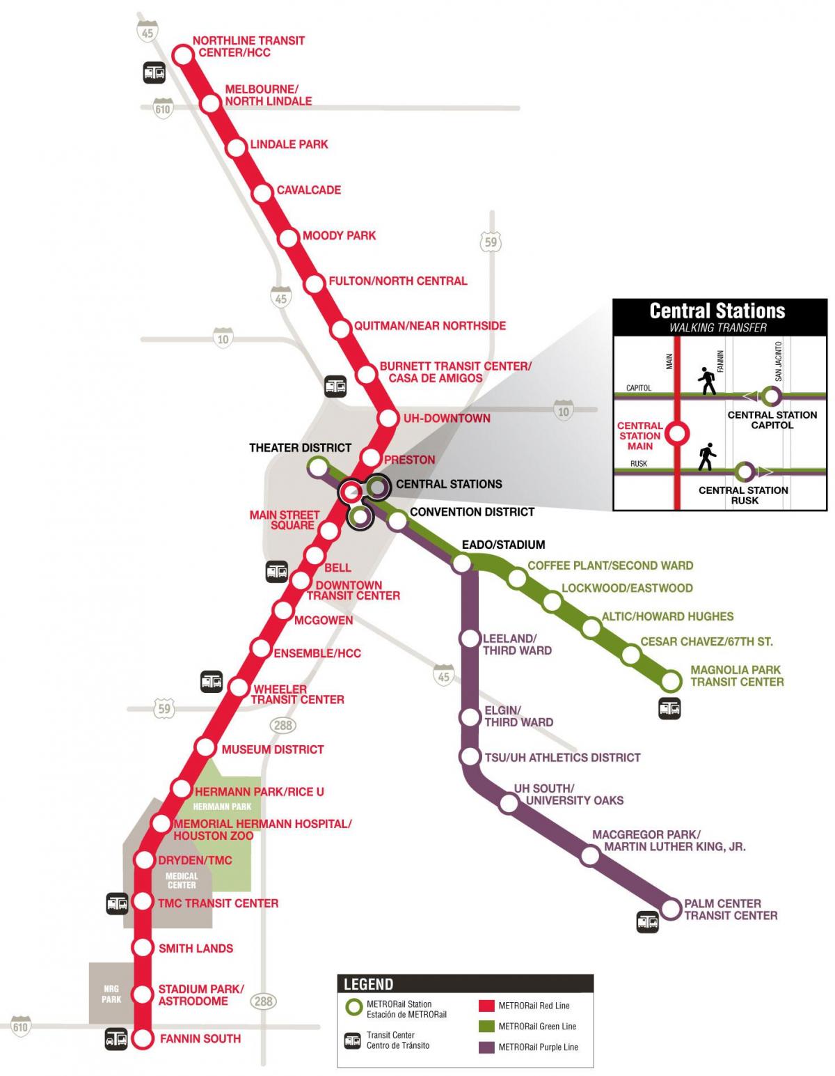
Get on track with Houston METRORail a fast, convenient way to travel to downtown, midtown, the Museum District, Texas Medical Center, Moody Park and up to the Northline Transit Center / HCC as its shown in Metro map Houston. Customers can carry a pet on the bus and the rail as long as it is caged properly. Service animals are allowed to accompany riders with disabilities. Bus and rail riders may bring car seats aboard, but there are no seat belts to strap the car seat to the bus or rail seat. So the caregiver would have to hold the baby or child. Strollers are also allowed. On buses, we suggest removing the child from the stroller and folding the stroller while on-board. The 13-mile Red Line (formerly the Main Street Line) opened in 2004 and today carries an extraordinary 48,000 passengers daily, making it one of the nation most traveled lines based on boardings per track mile. The Red Line was expanded in December 2013, offering fast and convenient rail service from the Northline Transit Center/HCC to Fannin South and numerous points in between. Featured stops include downtown, the Museum District, the Texas Medical Center and NRG Park.
The Green Line (East End) travels along Harrisburg from the Magnolia Park Transit Center and through the historic East End to a variety of downtown entertainment and business destinations as you can see in Metro map Houston. The portion of the track closest to downtown will be shared with the Purple Line (Southeast). From the EaDo / Stadium Station, passengers can transfer to the Purple Line and travel to the University of Houston central campus and the Palm Center Transit Center. Green Line riders can also hop on the Red Line at Central Station Main for travel up and down Main Street. There is more to building a successful light-rail system than laying track and putting up stations. That is why METRORail made a commitment to not only serve and connect Houston communities, but also to maintain their culture and integrity. METRORail has added more than 17 miles of new sidewalks and 45 miles of 12-foot traffic lanes. The expanded light-rail system that now runs nearly 23 miles is an essential element of the city plans to meet the transportation and environmental challenges of today and tomorrow, easing our growing traffic congestion and improving air quality.
The 6.6-mile Purple Line (Southeast) begins downtown and travels southeast along Capitol and Rusk to the Palm Center near MLK and Griggs as its mentioned in Metro map Houston. The Purple line runs through one of Houston oldest African-American communities and connects to both Texas Southern University and the University of Houston. The last section of the trackway is shared with the Green Line (East End), which will enable riders to transfer at the EaDo/Stadium Station to travel through the historic East End. Riders can also transfer to the Red Line at Central Station Main, where they can travel up and down Main Street. The METRORapid Silver Line (route no. 433) runs along Post Oak Blvd. through the Galleria area, connecting Uptown Houston to two major transit centers.

The Houston subway map shows all the stations and lines of the Houston subway. This subway map of Houston will allow you to easily plan your routes in the subway of Houston en Texas - USA. The Houston subway map is downloadable in PDF, printable and free.
The METRORail has three lines, but the longest and most utilized is the Red Line. This track connects some of Houston busiest neighborhoods, including downtown, Midtown, the Museum District and the Texas Medical Center as you can see in Houston subway map. The other two lines cross the Red Line downtown to get from the Theater District to EaDo. METRORail offers convenient and accessible service within the heart of the city between downtown Houston and NRG Park, including the Museum District and Texas Medical Center. Two additional lines connect the Theater District with BBVA Compass Stadium and destinations east of downtown. Six routes offer local service to the University of Houston main campus. Connect via transit centers to a network of additional local and Park and Ride routes providing service across the Houston metro area.
Depending on the time of day, trains come every 6-20 minutes, though that can vary. Hours are: Monday - Thursday, 3:30 a.m - midnight; Friday, 4:30 a.m. - 2:20 a.m.; Saturday, 5:30 a.m. - 2:20 a.m. and Sunday, 5:30 a.m. - 11:40 p.m as its shown in Houston subway map. There are a lot of ways to pay for METRO buses and trains — most of which can be purchased online or at a local grocery store. Most Houstonians who take public transit use their own Q Fare cards. These cards work a little like digital wallets, where you wave them in front of the Q card reader (look for a large red circle) to pay. You can order the cards online, with the option to refill them automatically when the balance gets low. After every 50 rides, you get five rides free. The Q-Ticketing app (free in the App Store and Google Play) lets you buy a single fare or a day pass from your phone, which you can then show to the bus driver or fare inspector.
METRO Day Pass: The day pass is a reloadable card like the Q card that gives you unlimited rides for $3 a day. You can buy it in the ticketing app, online, or at a Houston-area grocery store. METRO Money Card as its mentioned in Houston subway map: A little like gift cards, money cards are disposable, pre-loaded cards that can only be used for rides. Cards come in $1.25, $2.50, $5, $10, and $20 denominations and can not be reloaded. These can be ordered online. Cash: If you do not buy a pass beforehand, you can always pay with cash. Buses require exact change, but not trains. The platforms are equipped with a ticketing kiosk that will make change for larger bills. Credit Card: You can only use a credit card when buying a train ticket on the platform. The kiosk lets you reload your Q card or a buy a day pass or single ticket using a credit card, but it is not an option for buses.